
What problem this checklist solves
Mining sites lose hours, materials, and sometimes lives when they don’t know where machines are, how they’re performing, or whether drivers are following safe routes. This checklist begins with those failures and addresses them directly by showing practical steps to deploy GPS fleet trackers so your team can stop guessing and start managing risk. The problem is simple: limited visibility creates preventable incidents and hidden costs. The solutions below target visibility, accountability, and predictable maintenance.
Immediate risks to stop first
Begin with the highest-consequence problems. They’re the easiest to justify and the hardest to ignore.
- Vehicle collisions in blind zones — lack of real-time position data.
- Unauthorized equipment movement — hours lost to searching for machines.
- Unplanned downtime — missed maintenance windows because usage data is absent.
- Regulatory gaps — missing searchable records for incident investigations.
Addressing these removes the most direct threats to safety and production.
Minimum viable implementation checklist
Use this sequence on site. Each step is practical and measurable.
- Define objectives: safety, utilization, compliance — pick one priority to prove value within 30 days.
- Survey assets: list make/model, CAN-bus availability, and primary operating zones (pit, ROM, haul roads).
- Select hardware compatible with heavy mining conditions (IP67+, wide-temp rating, vibration tolerant).
- Plan connectivity: cellular primary, satellite fallback for remote pits; prioritize sites by risk exposure.
- Install baseline geofences around hazardous zones and processing plants before full rollout.
- Integrate telematics with dispatch, maintenance, and HSE logs for a single view.
- Train two crews: operators on in-cab alerts; supervisors on exception workflows.
- Run a 30-day pilot on the highest-risk shift, measure incidents and mean time to locate assets.
Each item here reduces specific hazards or failure modes. Measure outcomes with simple KPIs: time-to-locate, unexpected stops per 1,000 hours, and on-time maintenance rate.
Technical selection: what to require from devices and platforms
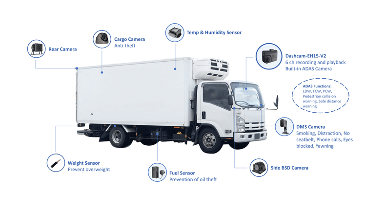
Pick gear that answers operational needs, not marketing. For fleet tracking prioritize ruggedness, integration options, and data fidelity. Where appropriate, use gps tracking for fleet vehicles that offer:
- High-sensitivity GNSS with dead-reckoning for tunnels and pit walls.
- Direct CAN-bus or OBD-II read capability for fuel, hours, fault codes.
- Configurable geofencing and tamper alerts.
- Local data buffering to survive spotty coverage.
- Open APIs for dispatch, maintenance, and safety systems.
Demand real-world uptime numbers and a warranty that covers shock and ingress. Ask vendors for on-site reference installations in climates like yours.
Common implementation pitfalls and how to avoid them
Teams stumble when expectations and operations diverge. Watch for these mistakes.
- Overloading the pilot: trying to measure every metric at once. Start simple.
- Ignoring operator feedback: devices that block cab view or produce false alarms get disabled fast.
- Assuming coverage equals usability: a signal indicator is not the same as reliable position reporting.
- Skipping maintenance integration: tracking without automated service triggers leaves data unused.
Prevent these by enforcing a pilot governance plan, committing to daily checks for two weeks, and iterating on device configuration based on operator input.
Data use and governance — make the data work for safety
Raw location data means little unless paired with rules and accountability.
- Define who owns each data stream and who can change geofence rules.
- Create automated exceptions: overspeed events, idle time beyond threshold, or entry into exclusion zones.
- Set retention and export policies aligned with regulators and internal incident processes.
- Use simple dashboards for supervisors and detailed exports for investigations.
Keep analytics focused on decisions: decide what action follows an alert before you enable the alert.
Operational rollout and scaling
Move from pilot to fleet in controlled waves.
- Wave 1: critical equipment on highest-risk shifts.
- Wave 2: complete pit and haulage routes, add maintenance triggers.
- Wave 3: peripheral assets and contractor fleets, unify billing and access.
Assign a rollout owner, a technical owner, and an operator champion. Expect configuration tweaks after each wave based on field feedback.
A real-world anchor: where this approach matters
Large haul operations in regions like the Pilbara region of Western Australia face long haul roads, heavy loads, and remote communications challenges. Teams there commonly deploy position-aware systems to manage safety on steep grades and optimize dispatch windows. Observing those practices helps shape realistic expectations for device resilience and network design.
Quick checklist for day-one verification
Before you declare success, verify these:
- Real-time position updates at expected intervals in operational zones.
- Geofence alert firing in supervised tests.
- CAN/engine hours recorded and matched to fuel logs.
- Operator acknowledgment workflows are used and logged.
If any item fails, pause expansion and correct the cause. Small fixes now prevent large incidents later.
Closing synthesis
Start by fixing the single biggest visibility gap, prove impact in a controlled pilot, then expand with clear rules for data, device standards, and operator involvement. Practical steps reduce incidents, clarify accountability, and preserve uptime. A straightforward deployment built to these checks will show immediate value and scale predictably — as demonstrated in field deployments and standard mining practice — and it’s the kind of practical, site-focused solution a partner like BSJ can align with your operational needs without adding complexity.